Popular Cartography Books
30+ [Hand Picked] Popular Books On Cartography
Discover the list of some best books written on Cartography by popular award winning authors. These book on topic Cartography highly popular among the readers worldwide.

The Map Thief by Michael Blanding
The story of an infamous crime, a revered map dealer with an unsavory secret, and the ruthless subculture that consumed him Maps have long exerted a special fascination on viewers—both as beautiful works of art and as practical tools to navigate the world. But to those who collect them, the map trade can be a cutthroat business, inhabited by quirky and sometimes disreputab The story of an infamous crime, a revered map dealer with an unsavory secret, and the ruthless subculture that consumed him Maps have long exerted a special fascination on viewers—both as beautiful works of art and as practical tools to navigate the world. But to those who collect them, the map trade can be a cutthroat business, inhabited by quirky and sometimes disreputable characters in search of a finite number of extremely rare objects. Once considered a respectable antiquarian map dealer, E. Forbes Smiley spent years doubling as a map thief —until he was finally arrested slipping maps out of books in the Yale University library. The Map Thief delves into the untold history of this fascinating high-stakes criminal and the inside story of the industry that consumed him. Acclaimed reporter Michael Blanding has interviewed all the key players in this stranger-than-fiction story, and shares the fascinating histories of maps that charted the New World, and how they went from being practical instruments to quirky heirlooms to highly coveted objects. Though pieces of the map theft story have been written before, Blanding is the first reporter to explore the story in full—and had the rare privilege of having access to Smiley himself after he’d gone silent in the wake of his crimes. Moreover, although Smiley swears he has admitted to all of the maps he stole, libraries claim he stole hundreds more—and offer intriguing clues to prove it. Now, through a series of exclusive interviews with Smiley and other key individuals, Blanding teases out an astonishing tale of destruction and redemption. The Map Thief interweaves Smiley’s escapades with the stories of the explorers and mapmakers he knew better than anyone. Tracking a series of thefts as brazen as the art heists in Provenance and a subculture as obsessive as the oenophiles in The Billionaire’s Vinegar, Blanding has pieced together an unforgettable story of high-stakes crime.
I WANT TO READ THIS
Unruly Places: Lost Spaces, Secret Cities, and Other Inscrutable Geographies by Alastair Bonnett
A tour of the world’s hidden geographies—from disappearing islands to forbidden deserts—and a stunning testament to how mysterious the world remains todayAt a time when Google Maps Street View can take you on a virtual tour of Yosemite’s remotest trails and cell phones double as navigational systems, it’s hard to imagine there’s any uncharted ground left on the planet. In A tour of the world’s hidden geographies—from disappearing islands to forbidden deserts—and a stunning testament to how mysterious the world remains todayAt a time when Google Maps Street View can take you on a virtual tour of Yosemite’s remotest trails and cell phones double as navigational systems, it’s hard to imagine there’s any uncharted ground left on the planet. In Unruly Places, Alastair Bonnett goes to some of the most unexpected, offbeat places in the world to reinspire our geographical imagination. Bonnett’s remarkable tour includes moving villages, secret cities, no man’s lands, and floating islands. He explores places as disorienting as Sandy Island, an island included on maps until just two years ago despite the fact that it never existed. Or Sealand, an abandoned gun platform off the English coast that a British citizen claimed as his own sovereign nation, issuing passports and crowning his wife as a princess. Or Baarle, a patchwork of Dutch and Flemish enclaves where walking from the grocery store’s produce section to the meat counter can involve crossing national borders. An intrepid guide down the road much less traveled, Bonnett reveals that the most extraordinary places on earth might be hidden in plain sight, just around the corner from your apartment or underfoot on a wooded path. Perfect for urban explorers, wilderness ramblers, and armchair travelers struck by wanderlust, Unruly Places will change the way you see the places you inhabit.
I WANT TO READ THIS
An Atlas of Countries That Don't Exist: A Compendium of Fifty Unrecognized and Largely Unnoticed States by Nick Middleton
Acclaimed travel writer and Oxford geography don Nick Middleton takes us on a magical tour of countries that, lacking diplomatic recognition or UN membership, inhabit a world of shifting borders, visionary leaders and forgotten peoples. Most of us think we know what a country is, but in truth the concept is rather slippery. From Catalonia to the Crimea, and from Africa's la Acclaimed travel writer and Oxford geography don Nick Middleton takes us on a magical tour of countries that, lacking diplomatic recognition or UN membership, inhabit a world of shifting borders, visionary leaders and forgotten peoples. Most of us think we know what a country is, but in truth the concept is rather slippery. From Catalonia to the Crimea, and from Africa's last colony to the European republic that enjoyed just a solitary day of independence, the places in this book may lie on the margins of legitimacy, but all can be visited in the real world. Beautifully illustrated by fifty regional maps, each shadowy country is literally cut out of the page of this book. Alongside stories, facts and figures, this Atlas brings to life a dreamlike world of nations that exist only in the minds of the people who live there.
I WANT TO READ THIS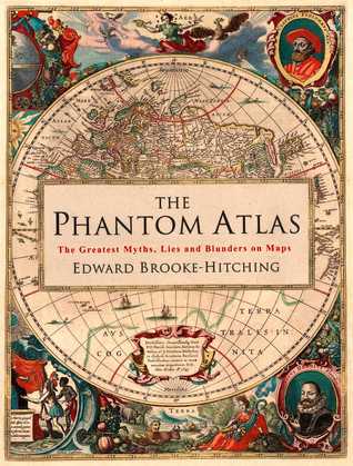
The Phantom Atlas: The Greatest Myths, Lies and Blunders on Maps by Edward Brooke-Hitching
The Phantom Atlas is an atlas of the world not as it ever existed, but as it was thought to be. These marvellous and mysterious phantoms - non-existent islands, invented mountain ranges, mythical civilisations and other fictitious geography - were all at various times presented as facts on maps and atlases. This book is a collection of striking antique maps that display th The Phantom Atlas is an atlas of the world not as it ever existed, but as it was thought to be. These marvellous and mysterious phantoms - non-existent islands, invented mountain ranges, mythical civilisations and other fictitious geography - were all at various times presented as facts on maps and atlases. This book is a collection of striking antique maps that display the most erroneous cartography, with each illustration accompanied by the story behind it. Exploration, map-making and mythology are all brought together to create a colourful tapestry of monsters, heroes and volcanoes; swindlers, mirages and murderers. Sometimes the stories are almost impossible to believe, and remarkably, some of the errors were still on display in maps published in the 21st century. Throughout much of the 19th century more than 40 different mapmakers included the Mountains of Kong, a huge range of peaks stretching across the entire continent of Africa, in their maps - but it was only in 1889 when Louis Gustave Binger revealed the whole thing to be a fake. For centuries, explorers who headed to Patagonia returned with tales of the giants they had met who lived there, some nine feet tall. Then there was Gregor MacGregor, a Scottish explorer who returned to London to sell shares in a land he had discovered in South America. He had been appointed the Cazique of Poyais, and bestowed with many honours by the local king of this unspoiled paradise. Now he was offering others the chance to join him and make their fortune there, too - once they had paid him a bargain fee for their passage... The Phantom Atlas is a beautifully produced volume, packed with stunning maps and drawings of places and people that never existed. The remarkable stories behind them all are brilliantly told by Edward Brooke-Hitching in a book that will appeal to cartophiles everywhere.
I WANT TO READ THIS
Plotted: A Literary Atlas by Andrew DeGraff , Daniel G. Harmon (Essays)
This incredibly wide-ranging collection of maps - all inspired by literary classics - offers readers a new way of looking at their favorite fictional worlds. Andrew DeGraff's stunningly detailed artwork takes readers deep into the landscapes from The Odyssey, Hamlet, Pride and Prejudice, Invisible Man, A Wrinkle in Time, Watership Down,A Christmas Carol, and more. Sure to This incredibly wide-ranging collection of maps - all inspired by literary classics - offers readers a new way of looking at their favorite fictional worlds. Andrew DeGraff's stunningly detailed artwork takes readers deep into the landscapes from The Odyssey, Hamlet, Pride and Prejudice, Invisible Man, A Wrinkle in Time, Watership Down,A Christmas Carol, and more. Sure to reignite a love for old favorites and spark fresh interest in more recent works as well, Plotted provides a unique new way of appreciating the lands of the human imagination.
I WANT TO READ THIS
How to Draw Fantasy Art and RPG Maps: Step by Step Cartography for Gamers and Fans by Jared Blando
The power of creation is at your fingertips!Orcs prepare for battle against high Elves, Dwarves retreat to the mountains and men march to the sea to reclaim crumbling fortresses. Fortunes are decided. Kingdoms are lost. Entire worlds are created. This book will teach you to bring your fictional realm to life with simple step-by-step instructions on how to draw authentic fa The power of creation is at your fingertips!Orcs prepare for battle against high Elves, Dwarves retreat to the mountains and men march to the sea to reclaim crumbling fortresses. Fortunes are decided. Kingdoms are lost. Entire worlds are created. This book will teach you to bring your fictional realm to life with simple step-by-step instructions on how to draw authentic fantasy maps. Set the stage for adventure by illustrating domains, castles and battle lines, mountains, forests and sea monsters! Learn to create completely unique and fully functional RPG maps time and time again on which your world can unfold.All the skills necessary to create awe-inspiring maps are covered! Landscapes. Add depth, balance and plausibility with rocky coastlines, towering mountains, dark forests and rolling plains. Iconography. Mark important places--towns and cities, fortresses and bridges--with symbolic iconography for easy-to-understand maps. Typography. Learn how to place readable text and the basics of decorative script. Bonus instruction teaches you to create fonts for Orcs, Elves, Vikings and dragons. Heraldry and shield design. Depict cultural and political boundaries with shields and colors. Advanced cartography. Includes how to draw landmarks, country boundaries and political lines. Build roads to connect merchants and troops, troll cairns and dragon lairs. And complete your maps with creative backgrounds, elaborate compasses and thematic legends. 30+ step-by-step demonstrations illustrate how to construct an entire fantasy world map from start to finish--both digitally and by hand!
I WANT TO READ THIS
Vargic's Miscellany of Curious Maps by Martin Vargic
EXPLORE THE WORLD AS YOU NEVER KNEW IT WITH VARGIC'S ASTONISHING MISCELLANY OF CURIOUS MAPS. Vargic's Miscellany is a collection of 64 maps and infographics. See the world mapped out by stereotypes; discover the Internet in cartographical form; marvel at the maps of global technology and culture; and explore the world through infographics and statistics. This wonderful and st EXPLORE THE WORLD AS YOU NEVER KNEW IT WITH VARGIC'S ASTONISHING MISCELLANY OF CURIOUS MAPS. Vargic's Miscellany is a collection of 64 maps and infographics. See the world mapped out by stereotypes; discover the Internet in cartographical form; marvel at the maps of global technology and culture; and explore the world through infographics and statistics. This wonderful and strange atlas is a treasure trove of interesting, unexpected and bizarre facts - a glorious celebration of our big beautiful diverse world. Includes: The Map of Stereotypes Maps of Internet, YouTube and Gaming Maps of Literature, Music and Sport The Map of Separatist Europe 51 infographic maps - from lighting strikes to sexual partners, heavy metal bands to tractors And many more . . .
I WANT TO READ THIS
Great Maps by Jerry Brotton
The world's finest maps explored and explained. From Ptolemy's world map to the Hereford's Mappa Mundi, through Mercator's map of the world to the latest maps of the Moon and Google Earth, Great Maps provides a fascinating overview of cartography through the ages. Revealing the stories behind 55 historical maps by analyzing graphic close-ups, Great Maps also profiles key ca The world's finest maps explored and explained. From Ptolemy's world map to the Hereford's Mappa Mundi, through Mercator's map of the world to the latest maps of the Moon and Google Earth, Great Maps provides a fascinating overview of cartography through the ages. Revealing the stories behind 55 historical maps by analyzing graphic close-ups, Great Maps also profiles key cartographers and explorers to look why each map was commissioned, who it was for and how they influenced navigation, propaganda, power, art, and politics.
I WANT TO READ THIS
Unfathomable City: A New Orleans Atlas by Rebecca Solnit , Rebecca Snedeker
Like the bestselling Infinite City: A San Francisco Atlas, this book is a brilliant reinvention of the traditional atlas, one that provides a vivid, complex look at the multi-faceted nature of New Orleans, a city replete with contradictions. More than twenty essays assemble a chorus of vibrant voices, including geographers, scholars of sugar and bananas, the city's remarka Like the bestselling Infinite City: A San Francisco Atlas, this book is a brilliant reinvention of the traditional atlas, one that provides a vivid, complex look at the multi-faceted nature of New Orleans, a city replete with contradictions. More than twenty essays assemble a chorus of vibrant voices, including geographers, scholars of sugar and bananas, the city's remarkable musicians, prison activists, environmentalists, Arab and Native voices, and local experts, as well as the coauthors' compelling contributions. Featuring 22 full-color two-page-spread maps, Unfathomable City plumbs the depths of this major tourist destination, pivotal scene of American history and culture and, most recently, site of monumental disasters such as Hurricane Katrina and the BP oil spill. The innovative maps' precision and specificity shift our notions of the Mississippi, the Caribbean, Mardi Gras, jazz, soils and trees, generational roots, and many other subjects, and expand our ideas of how any city is imagined and experienced. Together with the inspired texts, they show New Orleans as both an imperiled city--by erosion, crime, corruption, and sea level rise--and an ageless city that lives in music as a form of cultural resistance. Compact, lively, and completely original, Unfathomable City takes readers on a tour that will forever change the way they think about place. Read an excerpt here: Unfathomable City: A New Orleans Atlas by Rebecca Solnit and Rebecca Snedeker by University of California Press Listen to an interview with the authors here: http://www.ucpress.edu/blog/16097/new...
I WANT TO READ THIS
Maps by Aleksandra Mizielinska , Daniel Mizielinski
Travel the world without leaving your living room. Much more than an ordinary atlas, this book of maps is a visual feast for readers of all ages, with lavishly drawn illustrations from the incomparable Mizielinskis. It features not only borders, cities, rivers, and peaks, but also places of historical and cultural interest, eminent personalities, iconic animals and plants, Travel the world without leaving your living room. Much more than an ordinary atlas, this book of maps is a visual feast for readers of all ages, with lavishly drawn illustrations from the incomparable Mizielinskis. It features not only borders, cities, rivers, and peaks, but also places of historical and cultural interest, eminent personalities, iconic animals and plants, cultural events, and many more fascinating facts associated with every region of our planet.
I WANT TO READ THIS
On the Map: A Mind-Expanding Exploration of the Way the World Looks by Simon Garfield , Dava Sobel (Foreword)
Cartography enthusiasts rejoice: the bestselling author of the Just My Type reveals the fascinating relationship between man and map. Simon Garfield’s Just My Type illuminated the world of fonts and made everyone take a stand on Comic Sans and care about kerning. Now Garfield takes on a subject even dearer to our fanatical human hearts: maps. Imagine a world without maps. Ho Cartography enthusiasts rejoice: the bestselling author of the Just My Type reveals the fascinating relationship between man and map. Simon Garfield’s Just My Type illuminated the world of fonts and made everyone take a stand on Comic Sans and care about kerning. Now Garfield takes on a subject even dearer to our fanatical human hearts: maps. Imagine a world without maps. How would we travel? Could we own land? What would men and women argue about in cars? Scientists have even suggested that mapping—not language—is what elevated our prehistoric ancestors from ape-dom. Follow the history of maps from the early explorers’ maps and the awe-inspiring medieval Mappa Mundi to Google Maps and the satellite renderings on our smartphones, Garfield explores the unique way that maps relate and realign our history—and reflect the best and worst of what makes us human. Featuring a foreword by Dava Sobel and packed with fascinating tales of cartographic intrigue, outsize personalities, and amusing “pocket maps” on an array of subjects from how to fold a map to the strangest maps on the Internet, On the Map is a rich historical tapestry infused with Garfield’s signature narrative flair. Map-obsessives and everyone who loved Just My Type will be lining up to join Garfield on his audacious journey through time and around the globe.
I WANT TO READ THIS
The Vanishing Island by Barry Wolverton
Does the Vanishing Island really exist? And if so, what treasure—or terrible secret—was hidden by its disappearance? It’s 1599, the Age of Discovery in Europe. But for Bren Owen, growing up in the small town of Map on the coast of Britannia has meant anything but adventure. Enticed by the tales sailors have brought through Map’s port, and inspired by the arcane maps his fat Does the Vanishing Island really exist? And if so, what treasure—or terrible secret—was hidden by its disappearance? It’s 1599, the Age of Discovery in Europe. But for Bren Owen, growing up in the small town of Map on the coast of Britannia has meant anything but adventure. Enticed by the tales sailors have brought through Map’s port, and inspired by the arcane maps his father creates as a cartographer for the cruel and charismatic map mogul named Rand McNally, Bren is convinced that fame and fortune await him elsewhere. That is, until his repeated attempts to run away land him a punishment worse than death—cleaning up the town vomitorium. It is there that Bren meets a dying sailor, who gives him a strange gift that hides a hidden message. Cracking the code could lead Bren to a fabled lost treasure that could change his life forever, and that of his widowed father. But to get there he will have to tie his fate to a mysterious Dutch admiral obsessed with a Chinese legend about an island that long ago disappeared from any map. Before long, Bren is in greater danger than he ever imagined, and will need the help of an unusual friend named Mouse to survive. Barry Wolverton’s thrilling adventure spans oceans and cultures, brings together the folklore of East and West, and proves that fortune is always a double-edged sword.
I WANT TO READ THIS
The Measure of Manhattan: The Tumultuous Career and Surprising Legacy of John Randel, Jr., Cartographer, Surveyor, Inventor by Marguerite Holloway
John Randel Jr. (1787–1865) was an eccentric and flamboyant surveyor. Renowned for his inventiveness as well as for his bombast and irascibility, Randel was central to Manhattan’s development but died in financial ruin. Telling Randel’s engrossing and dramatic life story for the first time, this eye-opening biography introduces an unheralded pioneer of American engineering John Randel Jr. (1787–1865) was an eccentric and flamboyant surveyor. Renowned for his inventiveness as well as for his bombast and irascibility, Randel was central to Manhattan’s development but died in financial ruin. Telling Randel’s engrossing and dramatic life story for the first time, this eye-opening biography introduces an unheralded pioneer of American engineering and mapmaking. Charged with “gridding” what was then an undeveloped, hilly island, Randel recorded the contours of Manhattan down to the rocks on its shores. He was obsessed with accuracy and steeped in the values of the Enlightenment, in which math and science promised dominion over nature. The result was a series of maps, astonishing in their detail and precision, which undergird our knowledge about the island today. During his varied career Randel created surveying devices, designed an early elevated subway, and proposed a controversial alternative route for the Erie Canal—winning him admirers and enemies. The Measure of Manhattan is more than just the life of an unrecognized engineer. It is about the ways in which surveying and cartography changed the ground beneath our feet. Bringing Randel’s story into the present, Holloway travels with contemporary surveyors and scientists trying to envision Manhattan as a wild island once again. Illustrated with dozens of historical images and antique maps, The Measure of Manhattan is an absorbing story of a fascinating man that captures the era when Manhattan—indeed, the entire country—still seemed new, the moment before canals and railroads helped draw a grid across the American landscape.
I WANT TO READ THIS
Great City Maps by Jeremy Black (General Consultant) , Andrew Heritage (Contributor) , Andrew Humphreys (Contributor) , Thomas Cussans (Contributor)
A beautifully illustrated history of the world's most celebrated historical city maps, from the hubs of ancient civilization to sprawling modern mega-cities, created in association with the Smithsonian Institution. Great City Maps explores and explains 30 of the world's greatest historical city maps, providing a captivating overview of cartography through the ages. The book A beautifully illustrated history of the world's most celebrated historical city maps, from the hubs of ancient civilization to sprawling modern mega-cities, created in association with the Smithsonian Institution. Great City Maps explores and explains 30 of the world's greatest historical city maps, providing a captivating overview of cartography through the ages. The book's unrivaled reproduction of these fascinating and intricate documents provides graphic close-ups and reveals more than just pure geography-it offers insight into the cultures and beliefs of the great civilizations that gave rise to them. From classical cities like Rome and Jerusalem to modern hubs like New York and Tokyo, the stories behind each map are revealed: why it was created, who it was intended for, and how it was achieved. Profiles of key cartographers, planners, and artists give even further insight into the history of each urban masterpiece. With its genuinely unique and superbly illustrated approach to the most celebrated city maps in history and its lavish textured and foiled jacket, Great City Maps is a beautiful piece to add to any collection and a must-have for all history and geography enthusiasts.
I WANT TO READ THIS
A History of the World in 12 Maps by Jerry Brotton
A fascinating look at twelve maps—from Ancient Greece to Google Earth—and how they changed our world In this masterful study, historian and cartography expert Jerry Brotton explores a dozen of history’s most influential maps, from stone tablet to vibrant computer screen. Starting with Ptolemy, "father of modern geography," and ending with satellite cartography, A History o A fascinating look at twelve maps—from Ancient Greece to Google Earth—and how they changed our world In this masterful study, historian and cartography expert Jerry Brotton explores a dozen of history’s most influential maps, from stone tablet to vibrant computer screen. Starting with Ptolemy, "father of modern geography," and ending with satellite cartography, A History of the World in 12 Maps brings maps from classical Greece, Renaissance Europe, and the Islamic and Buddhist worlds to life and reveals their influence on how we—literally—look at our present world. As Brotton shows, the long road to our present geographical reality was rife with controversy, manipulation, and special interests trumping science. Through the centuries maps have been wielded to promote any number of imperial, religious, and economic agendas, and have represented the idiosyncratic and uneasy fusion of science and subjectivity. Brotton also conjures the worlds that produced these notable works of cartography and tells the stories of those who created, used, and misused them for their own ends.
I WANT TO READ THIS
On the Map: A Mind-Expanding Exploration of the Way the World Looks by Simon Garfield , Dava Sobel (Foreword)
Cartography enthusiasts rejoice: the bestselling author of the Just My Type reveals the fascinating relationship between man and map. Simon Garfield’s Just My Type illuminated the world of fonts and made everyone take a stand on Comic Sans and care about kerning. Now Garfield takes on a subject even dearer to our fanatical human hearts: maps. Imagine a world without maps. Ho Cartography enthusiasts rejoice: the bestselling author of the Just My Type reveals the fascinating relationship between man and map. Simon Garfield’s Just My Type illuminated the world of fonts and made everyone take a stand on Comic Sans and care about kerning. Now Garfield takes on a subject even dearer to our fanatical human hearts: maps. Imagine a world without maps. How would we travel? Could we own land? What would men and women argue about in cars? Scientists have even suggested that mapping—not language—is what elevated our prehistoric ancestors from ape-dom. Follow the history of maps from the early explorers’ maps and the awe-inspiring medieval Mappa Mundi to Google Maps and the satellite renderings on our smartphones, Garfield explores the unique way that maps relate and realign our history—and reflect the best and worst of what makes us human. Featuring a foreword by Dava Sobel and packed with fascinating tales of cartographic intrigue, outsize personalities, and amusing “pocket maps” on an array of subjects from how to fold a map to the strangest maps on the Internet, On the Map is a rich historical tapestry infused with Garfield’s signature narrative flair. Map-obsessives and everyone who loved Just My Type will be lining up to join Garfield on his audacious journey through time and around the globe.
I WANT TO READ THIS
Maphead: Charting the Wide, Weird World of Geography Wonks by Ken Jennings
Maphead: Charting the Wide, Weird World of Geography Wonks is Ken's followup to his 2005 best-seller Brainiac. Much as Brainiac offered a behind-the-scenes look at the little-known demimonde of competitive trivia buffs, Maphead finally gives equal time to that other downtrodden underclass: America's map nerds. In a world where geography only makes the headlines when college Maphead: Charting the Wide, Weird World of Geography Wonks is Ken's followup to his 2005 best-seller Brainiac. Much as Brainiac offered a behind-the-scenes look at the little-known demimonde of competitive trivia buffs, Maphead finally gives equal time to that other downtrodden underclass: America's map nerds. In a world where geography only makes the headlines when college students are (endlessly) discovered to be bad at it, these hardy souls somehow thrive. Some crisscross the map working an endless geographic checklist: visiting all 3,143 U.S. counties, for example, or all 936 UNESCO World Heritage Sites. Some pore over million-dollar collections of the rarest maps of the past; others embrace the future by hunting real-world cartographic treasures like "geocaches" or "degree confluences" with GPS device in hand. Some even draw thousands of their own imaginary maps, lovingly detailing worlds that never were. Ken Jennings was a map nerd from a young age himself, you will not be surprised to learn, even sleeping with a bulky Hammond atlas at the side of his pillow, in lieu of the traditional Teddy bear. As he travels the nation meeting others of his tribe--map librarians, publishers, "roadgeeks," pint-sized National Geographic Bee prodigies, the computer geniuses behind Google Maps and other geo-technologies--he comes to admire these geographic obsessives. Now that technology and geographic illiteracy are increasingly insulating us from the lay of the land around us, we are going to be needing these people more than ever. Mapheads are the ones who always know exactly where they are--and where everything else is as well.
I WANT TO READ THIS
You Are Here: Personal Geographies and Other Maps of the Imagination by Katharine Harmon
Mapmaking fulfills one of our most ancient and deepseated desires: understanding the world around us and our place in it. But maps need not just show continents and oceans: there are maps to heaven and hell; to happiness and despair; maps of moods, matrimony, and mythological places. There are maps to popular culture, from Gulliver's Island to Gilligan's Island. There are Mapmaking fulfills one of our most ancient and deepseated desires: understanding the world around us and our place in it. But maps need not just show continents and oceans: there are maps to heaven and hell; to happiness and despair; maps of moods, matrimony, and mythological places. There are maps to popular culture, from Gulliver's Island to Gilligan's Island. There are speculative maps of the world before it was known, and maps to secret places known only to the mapmaker. Artists' maps show another kind of uncharted realm: the imagination. What all these maps have in common is their creators' willingness to venture beyond the boundaries of geography or convention. You Are Here is a wide-ranging collection of such superbly inventive maps. These are charts of places you're not expected to find, but a voyage you take in your mind: an exploration of the ideal country estate from a dog's perspective; a guide to buried treasure on Skeleton Island; a trip down the road to success; or the world as imagined by an inmate of a mental institution. With over 100 maps from artists, cartographers, and explorers, You are Here gives the reader a breath-taking view of worlds, both real and imaginary.
I WANT TO READ THIS
The Map That Changed the World by Simon Winchester
In 1793, a canal digger named William Smith made a startling discovery. He found that by tracing the placement of fossils, which he uncovered in his excavations, one could follow layers of rocks as they dipped and rose and fell -- clear across England and, indeed, clear across the world -- making it possible, for the first time ever, to draw a chart of the hidden underside In 1793, a canal digger named William Smith made a startling discovery. He found that by tracing the placement of fossils, which he uncovered in his excavations, one could follow layers of rocks as they dipped and rose and fell -- clear across England and, indeed, clear across the world -- making it possible, for the first time ever, to draw a chart of the hidden underside of the earth. Determined to expose what he realized was the landscape's secret fourth dimension, Smith spent twenty-two years piecing together the fragments of this unseen universe to create an epochal and remarkably beautiful hand-painted map. But instead of receiving accolades and honors, he ended up in debtors' prison, the victim of plagiarism, and virtually homeless for ten years more. Finally, in 1831, this quiet genius -- now known as the father of modern geology -- received the Geological Society of London's highest award and King William IV offered him a lifetime pension. The Map That Changed the World is a very human tale of endurance and achievement, of one man's dedication in the face of ruin. With a keen eye and thoughtful detail, Simon Winchester unfolds the poignant sacrifice behind this world-changing discovery.
I WANT TO READ THIS
Atlas of Remote Islands by Judith Schalansky , Christine Lo (Translator)
A rare and beautifully illustrated journey to fifty faraway worlds. There are still places on earth that are unknown. Visually stunning and uniquely designed, this wondrous book captures fifty islands that are far away in every sense-from the mainland, from people, from airports, and from holiday brochures. Author Judith Schalansky used historic events and scientific repor A rare and beautifully illustrated journey to fifty faraway worlds. There are still places on earth that are unknown. Visually stunning and uniquely designed, this wondrous book captures fifty islands that are far away in every sense-from the mainland, from people, from airports, and from holiday brochures. Author Judith Schalansky used historic events and scientific reports as a springboard for each island, providing information on its distance from the mainland, whether its inhabited, its features, and the stories that have shaped its lore. With full-color maps and an air of mysterious adventure, Atlas of Remote Island is perfect for the traveler or romantic in all of us.
I WANT TO READ THIS
How to Lie with Maps by Mark Monmonier
Originally published to wide acclaim, this lively, cleverly illustrated essay on the use and abuse of maps teaches us how to evaluate maps critically and promotes a healthy skepticism about these easy-to-manipulate models of reality. Monmonier shows that, despite their immense value, maps lie. In fact, they must. The second edition is updated with the addition of two new ch Originally published to wide acclaim, this lively, cleverly illustrated essay on the use and abuse of maps teaches us how to evaluate maps critically and promotes a healthy skepticism about these easy-to-manipulate models of reality. Monmonier shows that, despite their immense value, maps lie. In fact, they must. The second edition is updated with the addition of two new chapters, 10 color plates, and a new foreword by renowned geographer H. J. de Blij. One new chapter examines the role of national interest and cultural values in national mapping organizations, including the United States Geological Survey, while the other explores the new breed of multimedia, computer-based maps. To show how maps distort, Monmonier introduces basic principles of mapmaking, gives entertaining examples of the misuse of maps in situations from zoning disputes to census reports, and covers all the typical kinds of distortions from deliberate oversimplifications to the misleading use of color. "Professor Monmonier himself knows how to gain our attention; it is not in fact the lies in maps but their truth, if always approximate and incomplete, that he wants us to admire and use, even to draw for ourselves on the facile screen. His is an artful and funny book, which like any good map, packs plenty in little space."—Scientific American "A useful guide to a subject most people probably take too much for granted. It shows how map makers translate abstract data into eye-catching cartograms, as they are called. It combats cartographic illiteracy. It fights cartophobia. It may even teach you to find your way. For that alone, it seems worthwhile."—Christopher Lehmann-Haupt, The New York Times ". . . witty examination of how and why maps lie. [The book] conveys an important message about how statistics of any kind can be manipulated. But it also communicates much of the challenge, aesthetic appeal, and sheer fun of maps. Even those who hated geography in grammar school might well find a new enthusiasm for the subject after reading Monmonier's lively and surprising book."—Wilson Library Bulletin "A reading of this book will leave you much better defended against cheap atlases, shoddy journalism, unscrupulous advertisers, predatory special-interest groups, and others who may use or abuse maps at your expense."—John Van Pelt, Christian Science Monitor "Monmonier meets his goal admirably. . . . [His] book should be put on every map user's 'must read' list. It is informative and readable . . . a big step forward in helping us to understand how maps can mislead their readers."—Jeffrey S. Murray, Canadian Geographic
I WANT TO READ THIS
A History of the World in 12 Maps by Jerry Brotton
A fascinating look at twelve maps—from Ancient Greece to Google Earth—and how they changed our world In this masterful study, historian and cartography expert Jerry Brotton explores a dozen of history’s most influential maps, from stone tablet to vibrant computer screen. Starting with Ptolemy, "father of modern geography," and ending with satellite cartography, A History o A fascinating look at twelve maps—from Ancient Greece to Google Earth—and how they changed our world In this masterful study, historian and cartography expert Jerry Brotton explores a dozen of history’s most influential maps, from stone tablet to vibrant computer screen. Starting with Ptolemy, "father of modern geography," and ending with satellite cartography, A History of the World in 12 Maps brings maps from classical Greece, Renaissance Europe, and the Islamic and Buddhist worlds to life and reveals their influence on how we—literally—look at our present world. As Brotton shows, the long road to our present geographical reality was rife with controversy, manipulation, and special interests trumping science. Through the centuries maps have been wielded to promote any number of imperial, religious, and economic agendas, and have represented the idiosyncratic and uneasy fusion of science and subjectivity. Brotton also conjures the worlds that produced these notable works of cartography and tells the stories of those who created, used, and misused them for their own ends.
I WANT TO READ THIS
The Selected Works of T.S. Spivet by Reif Larsen , Ben Gibson (Book Design)
Discover The Selected Works of T.S. Spivet for iPad. A brilliant, boundary-leaping debut novel tracing twelve-year-old genius map maker T.S. Spivet's attempts to understand the ways of the world When twelve-year-old genius cartographer T.S. Spivet receives an unexpected phone call from the Smithsonian announcing he has won the prestigious Baird Award, life as normal-if you Discover The Selected Works of T.S. Spivet for iPad. A brilliant, boundary-leaping debut novel tracing twelve-year-old genius map maker T.S. Spivet's attempts to understand the ways of the world When twelve-year-old genius cartographer T.S. Spivet receives an unexpected phone call from the Smithsonian announcing he has won the prestigious Baird Award, life as normal-if you consider mapping family dinner table conversation normal-is interrupted and a wild cross-country adventure begins, taking T.S. from his family ranch just north of Divide, Montana, to the museum's hallowed halls. T.S. sets out alone, leaving before dawn with a plan to hop a freight train and hobo east. Once aboard, his adventures step into high gear and he meticulously maps, charts, and illustrates his exploits, documenting mythical wormholes in the Midwest, the urban phenomenon of "rims," and the pleasures of McDonald's, among other things. We come to see the world through T.S.'s eyes and in his thorough investigation of the outside world he also reveals himself. As he travels away from the ranch and his family we learn how the journey also brings him closer to home. A secret family history found within his luggage tells the story of T.S.'s ancestors and their long-ago passage west, offering profound insight into the family he left behind and his role within it. As T.S. reads he discovers the sometimes shadowy boundary between fact and fiction and realizes that, for all his analytical rigor, the world around him is a mystery. All that he has learned is tested when he arrives at the capital to claim his prize and is welcomed into science's inner circle. For all its shine, fame seems more highly valued than ideas in this new world and friends are hard to find. T.S.'s trip begins at the Copper Top Ranch and the last known place he stands is Washington, D.C., but his journey's movement is far harder to track: How do you map the delicate lessons learned about family and self? How do you depict how it feels to first venture out on your own? Is there a definitive way to communicate the ebbs and tides of heartbreak, loss, loneliness, love? These are the questions that strike at the core of this very special debut. Now a major motion picture directed by Jean-Pierre Jeunet and starring Kyle Catlett and Helena Bonham Carter.
I WANT TO READ THIS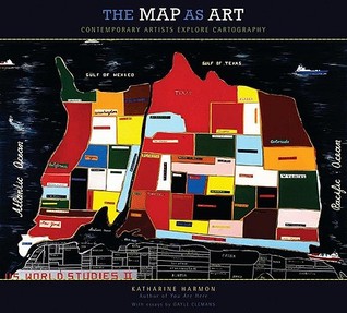
The Map As Art: Contemporary Artists Explore Cartography by Katharine Harmon , Gayle Clemans
Maps can be simple tools, comfortable in their familiar form. Or they can lead to different destinations: places turned upside down or inside out, territories riddled with marks understood only by their maker, realms connected more to the interior mind than to the exterior world. These are the places of artists' maps, that happy combination of information and illusion that Maps can be simple tools, comfortable in their familiar form. Or they can lead to different destinations: places turned upside down or inside out, territories riddled with marks understood only by their maker, realms connected more to the interior mind than to the exterior world. These are the places of artists' maps, that happy combination of information and illusion that flourishes in basement studios and downtown galleries alike. It is little surprise that, in an era of globalized politics, culture, and ecology, contemporary artists are drawn to maps to express their visions. Using paint, salt, souvenir tea towels, or their own bodies, map artists explore a world free of geographical constraints. Katharine Harmon knows this territory. As the author of our best-selling book You Are Here, she has inspired legions of new devotees of imaginative maps. In The Map as Art, Harmon collects 360 colorful, map-related artistic visions by well-known artistssuch as Ed Ruscha, Julian Schnabel, Olafur Eliasson, Maira Kalman, William Kentridge, and Vik Munizand many more less-familiar artists for whom maps are the inspiration for creating art. Essays by Gayle Clemans bring an in-depth look into the artists' maps of Joyce Kozloff, Landon Mackenzie, Ingrid Calame, Guillermo Kuitca, and Maya Lin. Together, the beautiful reproductions and telling commentary make this an essential volume for anyone open to exploring new paths.
I WANT TO READ THIS
The Island of Lost Maps: A True Story of Cartographic Crime by Miles Harvey
Now in paperback, this "USA Today" Best Book of 2000 tells the story of a curious crime spree: the theft of scores of valuable, centuries-old maps from some of the most prominent research libraries in the United States and Canada. When all was said and done, Gilbert Joseph Bland, Jr., had become the Al Capone of cartography. 20 illustrations throughout.
I WANT TO READ THIS
The Phantom Atlas: The Greatest Myths, Lies and Blunders on Maps by Edward Brooke-Hitching
The Phantom Atlas is an atlas of the world not as it ever existed, but as it was thought to be. These marvellous and mysterious phantoms - non-existent islands, invented mountain ranges, mythical civilisations and other fictitious geography - were all at various times presented as facts on maps and atlases. This book is a collection of striking antique maps that display th The Phantom Atlas is an atlas of the world not as it ever existed, but as it was thought to be. These marvellous and mysterious phantoms - non-existent islands, invented mountain ranges, mythical civilisations and other fictitious geography - were all at various times presented as facts on maps and atlases. This book is a collection of striking antique maps that display the most erroneous cartography, with each illustration accompanied by the story behind it. Exploration, map-making and mythology are all brought together to create a colourful tapestry of monsters, heroes and volcanoes; swindlers, mirages and murderers. Sometimes the stories are almost impossible to believe, and remarkably, some of the errors were still on display in maps published in the 21st century. Throughout much of the 19th century more than 40 different mapmakers included the Mountains of Kong, a huge range of peaks stretching across the entire continent of Africa, in their maps - but it was only in 1889 when Louis Gustave Binger revealed the whole thing to be a fake. For centuries, explorers who headed to Patagonia returned with tales of the giants they had met who lived there, some nine feet tall. Then there was Gregor MacGregor, a Scottish explorer who returned to London to sell shares in a land he had discovered in South America. He had been appointed the Cazique of Poyais, and bestowed with many honours by the local king of this unspoiled paradise. Now he was offering others the chance to join him and make their fortune there, too - once they had paid him a bargain fee for their passage... The Phantom Atlas is a beautifully produced volume, packed with stunning maps and drawings of places and people that never existed. The remarkable stories behind them all are brilliantly told by Edward Brooke-Hitching in a book that will appeal to cartophiles everywhere.
I WANT TO READ THIS
Cartographies of Time: A History of the Timeline by Daniel Rosenberg , Anthony Grafton
What does history look like? How do you draw time? From the most ancient images to the contemporary, the line has served as the central figure in the representation of time. The linear metaphor is ubiquitous in everyday visual representations of time—in almanacs, calendars, charts, and graphs of all sorts. Even our everyday speech is filled with talk of time having a "befor What does history look like? How do you draw time? From the most ancient images to the contemporary, the line has served as the central figure in the representation of time. The linear metaphor is ubiquitous in everyday visual representations of time—in almanacs, calendars, charts, and graphs of all sorts. Even our everyday speech is filled with talk of time having a "before" and an "after" or being "long" and "short." The timeline is such a familiar part of our mental furniture that it is sometimes hard to remember that we invented it in the first place. And yet, in its modern form, the timeline is not even 250 years old. The story of what came before has never been fully told, until now. Cartographies of Time is the first comprehensive history of graphic representations of time in Europe and the United States from 1450 to the present. Authors Daniel Rosenberg and Anthony Grafton have crafted a lively history featuring fanciful characters and unexpected twists and turns. From medieval manuscripts to websites, Cartographies of Time features a wide variety of timelines that in their own unique ways—curving, crossing, branching—defy conventional thinking about the form. A fifty-four-foot-long timeline from 1753 is mounted on a scroll and encased in a protective box. Another timeline uses the different parts of the human body to show the genealogies of Jesus Christ and the rulers of Saxony. Ladders created by missionaries in eighteenth-century Oregon illustrate Bible stories in a vertical format to convert Native Americans. Also included is the April 1912 Marconi North Atlantic Communication chart, which tracked ships, including the Titanic, at points in time rather than by theirgeographic location, alongside little-known works by famous figures, including a historical chronology by the mapmaker Gerardus Mercator and a chronological board game patented by Mark Twain. Presented in a lavishly illustrated edition, Cartographies of Time is a revelation to anyone interested in the role visual forms have played in our evolving conception of history.
I WANT TO READ THIS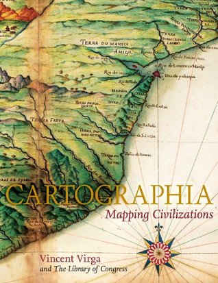
Cartographia: Mapping Civilizations by Vincent Virga , Library of Congress
CARTOGRAPHIA offers a stunning array of 200 of the most beautiful, important, and fascinating maps in existence, from the world's largest cartographic collection, at the Library of Congress. These maps show how our idea of the world has shifted and grown over time, and each map tells its own unique story about nations, politics, and ambitions. The chosen images, with thei CARTOGRAPHIA offers a stunning array of 200 of the most beautiful, important, and fascinating maps in existence, from the world's largest cartographic collection, at the Library of Congress. These maps show how our idea of the world has shifted and grown over time, and each map tells its own unique story about nations, politics, and ambitions. The chosen images, with their accompanying stories, introduce the reader to an exciting new way of "reading" maps as travelogues---living history from the earliest of man's imaginings about planet earth to our current attempts at charting cyberspace. Among the rare gems included in the book are the Waldseemuller Map of the World from 1507, the first to include the designation "America"; pages from the Ortelius's Theatrum Orbis Terrarum of 1570, considered the first modern atlas; rare maps from Africa, Asia, and Oceania that challenge traditional Western perspectives; William Faulkner's hand-drawn 1936 map of the fictional Yoknapatawpha County, Mississippi; and even a map of the Human Genome. In an oversized format, with gorgeous four-color reproductions throughout, Catrographia will appeal to collectors, historians, and anyone looking for a perfect gift.
I WANT TO READ THIS
The Mapmakers by John Noble Wilford
In his classic text, two-time Pulitzer Prize—winner John Noble Wilford recounts the history of cartography from antiquity to the space age. With this revised edition, Wilford brings the story up to the present day, as he shows the impact of new technologies that make it possible for cartographers to go where no one has been before, from the deepest reaches of the universe In his classic text, two-time Pulitzer Prize—winner John Noble Wilford recounts the history of cartography from antiquity to the space age. With this revised edition, Wilford brings the story up to the present day, as he shows the impact of new technologies that make it possible for cartographers to go where no one has been before, from the deepest reaches of the universe (where astronomers are mapping time as well as space) to the inside of the human brain. These modern-day mapmakers join the many earlier adventurers–including ancient Greek stargazers, Renaissance seafarers, and the explorers who mapped the American West–whose exploits shape this dramatic story of human inventiveness and limitless curiosity.
I WANT TO READ THIS
The Mapping of Love and Death by Jacqueline Winspear
In the latest mystery in the New York Times bestselling series, Maisie Dobbs must unravel a case of wartime love and death—an investigation that leads her to a long-hidden affair between a young cartographer and a mysterious nurse. August 1914. Michael Clifton is mapping the land he has just purchased in California's beautiful Santa Ynez Valley, certain that oil lies beneat In the latest mystery in the New York Times bestselling series, Maisie Dobbs must unravel a case of wartime love and death—an investigation that leads her to a long-hidden affair between a young cartographer and a mysterious nurse. August 1914. Michael Clifton is mapping the land he has just purchased in California's beautiful Santa Ynez Valley, certain that oil lies beneath its surface. But as the young cartographer prepares to return home to Boston, war is declared in Europe. Michael—the youngest son of an expatriate Englishman—puts duty first and sails for his father's native country to serve in the British army. Three years later, he is listed among those missing in action. April 1932. London psychologist and investigator Maisie Dobbs is retained by Michael's parents, who have recently learned that their son's remains have been unearthed in France. They want Maisie to find the unnamed nurse whose love letters were among Michael's belongings—a quest that takes Maisie back to her own bittersweet wartime love. Her inquiries, and the stunning discovery that Michael Clifton was murdered in his trench, unleash a web of intrigue and violence that threatens to engulf the soldier's family and even Maisie herself. Over the course of her investigation, Maisie must cope with the approaching loss of her mentor, Maurice Blanche, and her growing awareness that she is once again falling in love. Following the critically acclaimed bestseller Among the Mad, The Mapping of Love and Death delivers the most gripping and satisfying chapter yet in the life of Maisie Dobbs.
I WANT TO READ THIS